

![]()
If you ever have considered investigating or working with elements of the geospatial world, check out the latest edition of OSGeoLive.
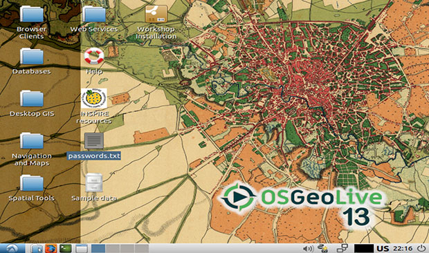
OSGeoLive is a Linux distribution that runs directly from a bootable DVD or USB thumb drive. You also can load a pre-made virtual machine disk file (vmdk) that runs in a VMware Workstation or VirtualBox environment. Or you can install it the old-fashioned way as a dual-boot or sole operating system on a hard drive.
Whichever approach you take, OSGeoLive gives you a complete Linux OS. If your work or hobby requires steady hands-on access to geospatial tools, you could use it as your primary OS.
Aside from the basic system tools and a few standard graphic and accessory applications, you would have to add from general software repositories applications such as office suites, audio and video tools. Adding your own to top off the specialized geospatial software that is included would give you a bloat-free computing platform.
This distro can serve your side interests, such as boating or traveling, by giving you portable and convenient access to navigational maps and other geospatial technologies, including storing, publishing, viewing, analyzing and manipulating data. It includes sample datasets, documentation and free world maps.
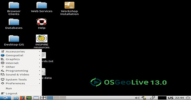
OSGeoLive is based on Lubuntu Linux and runs the LXDE desktop (Lightweight X11 Desktop Environment). It is interesting to note that the latest Lubuntu release earlier this year switched to the LXQt desktop (the Lightweight Qt Desktop Environment). LXQt was formed from the merger of the LXDE and Razor-qt projects.
When I downloaded the virtual machine disk edition last week I got OSGeoLive 13.0, which the Open Source Geospatial Foundation officially released today, Sept. 6, for DVD and USB as well.
Release highlights:
- New applications MapCache, GeoExt, t-rex, actinia;
- Additional Python modules like Fiona, rasterio, cartopy, pandas, geopandas, mappyfile;
- Improved documentation and four new translations, now supporting: English | Deutsch | Espanol | Suomi | Franais | Italiano | 日本語 | Hungarian; and
- Version updates to many of the included packages.
Geographic Information Management
This distro, sponsored by the OSGeo Foundation, is a specialty Linux offering with a following comprised of data specialists and science researchers as well as mapping enthusiasts. Geospatial technology refers to all of the technology used to acquire, manipulate and store geographic information.
The foundation is a not-for-profit organization supporting geospatial open source software development, promotion and education. The current versions of this distro reflect a refining of the number and types of included software. The focus seems to be packaging only leading geospatial and standard Linux system tools and applications. The emphasis pushes quality over quantity.
The software selections include some 50 high-quality geospatial open source applications installed and preconfigured with sample datasets. You also get free world maps and various project overviews with step-by-step quickstart guides for each geospatial application.
System requirements are fairly forgiving, thanks to the lightweight desktop environment the distro uses. OSGeoLive runs on a broad collection of legacy hardware.
Minimum suggested system resources are 1 GB RAM, although it's better to have 2 GB if you plan on trying the Java-based applications). You need a 1-GHz i386 or AMD64 compatible CPU. No hard drive is required, but a hard drive is needed if you want to have an installation that lets you save system settings and personal data.
Note that you can run this distro from the bootable DVD or USB installation. However, no persistent memory is available. You could get around that limitation by burning the ISO to a writable DVD or running the virtual machine disk version within your existing operating system installed on the hard drive.
OSGeoLive has an impressive inventory of geospatial software. Many of these titles are foundation projects. Some are standalone installed applications. Others are Web app connections that launch in the default Firefox Web browser from menus and desktop icons.
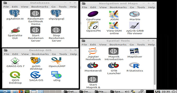
Spatial Toolbox
The Jupyter Notebook is a Web application to create and share documents that contain live code, equations, visualizations and explanatory text. Uses include data cleaning and transformation, numerical simulation, statistical modeling and machine learning.
Mapnik is a toolkit for rendering maps with clean, soft feature edges provided by quality anti-aliasing graphics, intelligent label placement and scalable, SVG symbolization. Mapnik is used to render the OpenStreetMap main map layers. It often is embedded in Python applications that deliver their maps over the Internet.
MapSlicer is a graphical application for online map publishing. You can use it to create overlays of standard maps like OpenStreetMap, Google Maps, Yahoo Maps or Bing Maps. Maps it creates can be visualized in 3D by Google Earth. Publishing your maps only requires uploading the automatically generated directory with tiles into your Web server.
The OTB/Monteverdi-based open source visualization tool handles your compression needs. This package is based on the Orfeo ToolBox (OTB). This is a CNES (French Spatial Agency) open source image processing library and the derived software Monteverdi. Monteverdi-Compression takes advantage of the visualization and image processing tools available in OTB and Monteverdi.
R Statistics uses the R Project for Statistical Computing. It is a free software environment for statistical computing and graphics.
Plotting Your Course
Tools for navigating and course planning are an integral part ofr the geospatial toolset this distro handles. For instance, GpsPrune is a tool for viewing, editing and converting coordinate data from GPS systems.
Use GPSPrune for planning trips or analyzing the tracks recorded by GPS receivers. It uses OpenStreetMap imagery to show recorded tracks and waypoints. It provides a variety of tools to let you edit, crop and prune the data points. It also has functions for correlating photos and audio files to the coordinates using the file timestamps.
GpsPrune uses Gpsbabel, if available, to read data directly from a GPS receiver and can send the edited data back to the receiver too.
JOSM or Jaffa OpenStreetMap Editor, is a desktop editing tool for OpenStreetMap geodata created in Java.
Marble is a virtual globe and world atlas. It is similar to a desktop globe. You can pan around and measure distances with it.
OpenCPN Chart Plotter Navigation is used by thousands of boaters as their main navigational tool for use under way or as a planning tool.
OpenStreetMap is the free wiki world map. Together you have land and sea routes completely covered.
Weather is another element critical to geospatial awareness. zyGrib is a program to download and visualize weather forecast data in the standard GRIB distribution format.
Default GIS Tools
Geographic Information System (GIS) tools are essential for handling geospatial surroundings on a computer. OSGeoLive gives you several options by default.
GRASS GIS, commonly referred to as GRASS (Geographic Resources Analysis Support System), is a free and open source Geographic Information System (GIS) software suite used for geospatial data management and analysis, image processing, graphics and maps production, spatial modeling and visualization.
gvSIG Desktop is a powerful, user-friendly, interoperable GIS used by thousands worldwide. It provides vector and raster file support, databases and remote services. This desktop offering provides a variety of tools to analyze and manage your geographic information.
OpenJUMP GIS is a Java-based vector and raster GIS and programming framework that enables users to display, edit, analyze and conflate geographic data. A similar tool is Open Source Desktop GIS for creating, editing, visualizing, analyzing and publishing geospatial information.
The SAGA GIS, or System for Automated Geoscientific Analyses, is a GIS computer program used to edit spatial data.
Another similar tool is uDig. It provides a complete Java solution for desktop GIS data access, editing and viewing.
More Geospatial Essentials
Databases and browser clients are the backbone of the geospatial toolset included in OSGeoLive platform.
pgAdmin III is a tool for working with the PostgreSQL Tools. It adds heightened functionality and convenience in handling PostgreSQL content.
Rasdaman (Raster Data Manager) is an Array Database Management System. In this distro Rasdaman is coupled with EarthLook to showcase standards-based services on Big Earth Data -- in particular, spatial-temporal coverage.
SHP2pgsql is a tool that generates an SQL script from ESRI shape and DBF files suitable for loading into a PostGIS enabled database. Spatialite GUI is an open source graphical user interface (GUI) tool supporting SpatiaLite, a spatial extension to SQLite that provides vector geodatabase functionality.
The Browser Clients menu is perhaps the largest collection of specialized geospatial tools in this distro. It is a collection of standalone tools you otherwise would have to track down and install on your own.
- GeoNode is a Web-based application and platform for developing geospatial information systems (GIS) and for deploying spatial data infrastructures (SDI);
- Cesium is a geospatial app with a simple workflow to create 3D maps of geospatial data for visualization, analysis and sharing;
- GeoExt is a JavaScript Toolkit for Rich Web Mapping Applications based on ExtJS and OpenLayers;
- GeoMoose 3 is a Web Client JavaScript Framework for displaying distributed cartographic data;
- Leaflet is a JavaScript library for mobile-friendly interactive maps;
- Mapbender is a Web-based geoportal framework to publish, register, view, navigate, monitor and grant secure access to spatial data infrastructure services;
- OpenLayers is a high-performance, feature-packed library for creating interactive maps on the Web;
- Geomajas is a collection of free and open source GIS libraries, tools and APIs for a complete end-to-end Web mapping solution.
In a Nutshell
OSGeoLive is a unique Linux distro. It pulls together a large library of Linux tools and applications that support geospatial workloads. It is not designed to be a general usability Linux operating system, but if you add the software it's missing, you can happily use it for other computing tasks.
I was particularly intrigued by some of its standalone applications and Web app offerings. Browsing through this distro's feature tools was a fun-filled discovery experience.
Nothing needed to be set up or configured. One click led to another. With each new screen came interesting information that teased my inquisitive mind. The experience actually sparked an interest in the world of geospatial elements.
Want to Suggest a Review?
Is there a Linux software application or distro you'd like to suggest for review? Something you love or would like to get to know?
Pleaseemail your ideas to me, and I'll consider them for a future Linux Picks and Pans column.
And use the Reader Comments feature below to provide your input!


This reminds me of Ubuntu Studio but different. It has a lot of software dedicated to one facet of science. Ubuntu Studio has a lot of software for audio and video editing and production.
When reviewing open source projects, I suggest assessing the health of the community behind the projects. In the case of OSGeoLive, we have simplified this process by collating available OpenHub metrics at https://live.osgeo.org/en/metrics.html
In your review, you’ve missed mentioning QGIS, which these metrics show as having one of the strongest communities behind it, (and by the way happens to be the first project I’d suggest most people start with if looking into geospatial applications).
Cheers, Cameron, one of the OSGeoLive coordinators.